Aid workers often work in very large areas
Volunteers at Missing Maps make a difference in humanitarian crises
© Frank Canters
© Frank Canters
Jane Frippiat
13 May 2025 • 5 minutes reading time
Relief organisations often work in areas where up-to-date digital maps do not exist. But to help stop the spread of epidemics or cope with victims of natural disasters, these are desperately needed. Missing Maps provides support, together with a global network of volunteers.
This article was translated from Dutch by kompreno, which provides high-quality, distraction-free journalism in five languages. Partner of the European Press Prize, kompreno curates top stories from 30+ sources across 15 European countries. Join here to support independent journalism.
‘One of the problems Médecins Sans Frontières faces in the field is that they do not always know exactly where the population lives because updated and digital maps of many areas are not always available,’ says Frank Canters, professor at the Department of Geography at VUB and director of the Cartography and Geoinformatics research group.
To support MSF’s field work, the organisation Missing Maps was set up in 2014, a collaboration between MSF, the Red Cross and the non-profit organisation Open Street Map Foundation.
The aim of this collaboration is to supplement map data from Open Street Map (OSM), a free online world map, so that Médecins Sans Frontières can use it to carry out humanitarian missions. It is important mainly to indicate buildings and roads to locate existing population concentrations.
Missing Maps relies on a global network of volunteers to do this. Anyone with a computer and internet connection can contribute to any project the organisation puts online. Everything is done completely remotely and requires no experience.
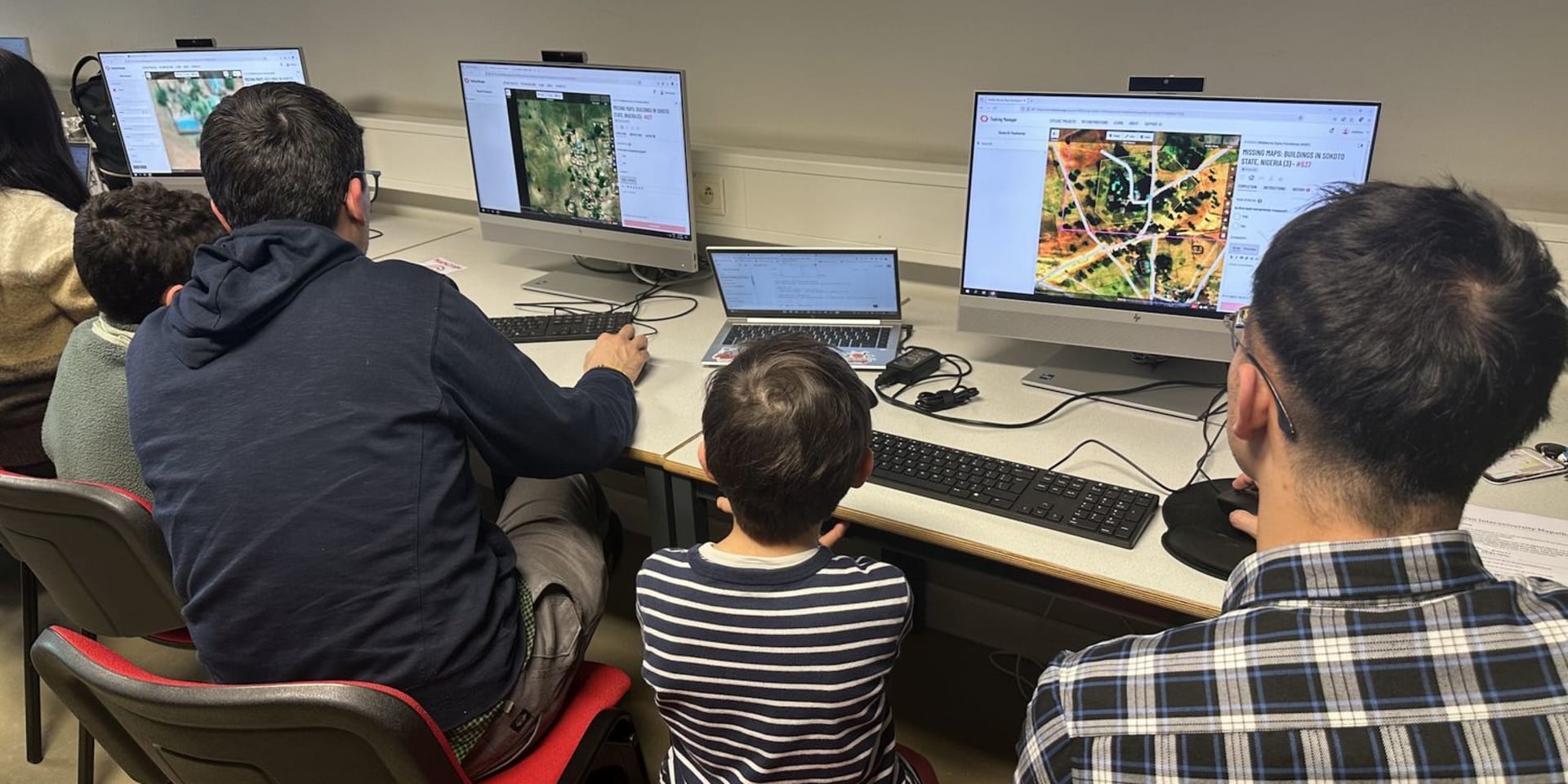
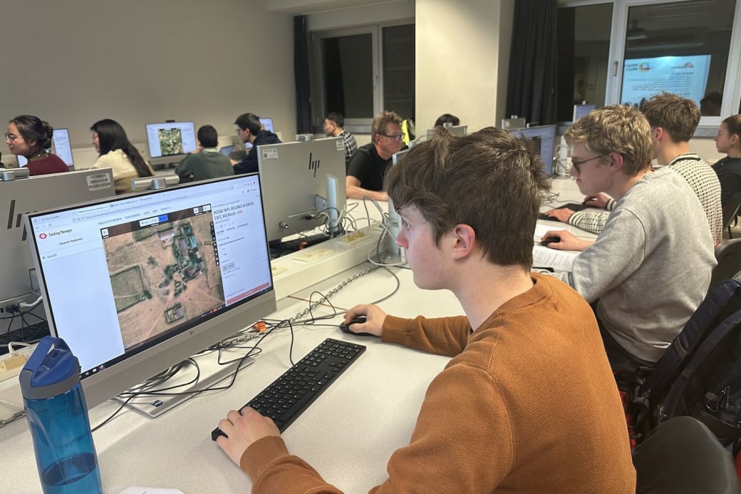
To make this process more efficient and recruit more volunteers, Missing Maps also organises Mapathons, events where people come together to map a particular area. Last March, a Belgian inter-university Mapathon took place, with volunteers completing OSM map data for the suburbs of the city of Sokoto in Nigeria over four evenings. MO* spoke with coordinator Frank Canters.
Support for aid workers
How can I participate in this project without experience?
Frank Canters: ‘That is very simple. You create an account on Tasking Manager, an OSM platform, and choose one of the projects. Then you are shown satellite images of a particular area. Those images are divided into small quadrangles of which you choose one. If you want to point out houses that day, you point out the corners of a house in the quadrangle. You save that as a building in the database. Then you designate the next house and that’s how you complete the quadrangle.’
How does this work by volunteers help emergency services?
Frank Canters: ‘Medecins Sans Frontieres aid workers often work in very vast areas, without knowing exactly where the population lives. They also often deal with displaced people who had to flee unprepared and have left everything behind. To make their campaigns as efficient as possible, it is indeed necessary to know where people live, or where they are, and how to reach them.’
‘Then again, the 2024 Belgian Inter-University Mapathon was dedicated to the floods in Chad. Due to climate change, the Sahel is increasingly facing heavy downpours. But this region has never seen much rainfall and the soil is unable to absorb large amounts of water. Entire areas can be flooded, causing people to lose their homes and food. Doctors Without Borders then tried to provide basic resources to people on the run.’
Missing Maps ook Mapathons, evenementen waarbij mensen samenkomen om een bepaald gebied te mappen.
© Frank Canters
Why did the 2025 Inter-University Mapathon focus on Sokoto?
Frank Canters: ‘The people of Sokoto are currently facing an outbreak of noma disease. This is a non-contagious bacterial disease that starts with inflammation of the gums and then spreads to the jawbone, nose and eyes. The disease mainly affects children under the age of seven and finds its cause in poor oral hygiene, a weak immune system and malnutrition. 90% of those who get infected die within the first two weeks.’
‘By restoring oral hygiene and quickly administering antibiotics, noma can be remedied very easily. Unfortunately, large chunks of the map of the Sokoto region have not yet been digitised and there is a great need for data collection honour aid workers to launch a vaccination campaign to stop the outbreak. That is why the 2025 Mapathon is mapping the existing populations of Sokoto.’
How does Médecins Sans Frontières choose which areas to map?
Frank Canters: ‘This is done both preventively and in response to a crisis situation. Many long-term projects combat malnutrition, for example. But to map a particular area as quickly as possible in certain crisis situations, MSF and the Red Cross use Missing Maps. And the Mapathons speed up this process.’
Reliability
Why does Médecins Sans Frontières not work with Google Street Maps?
Frank Canters: ‘Because it is a commercial product and therefore does not work disinterestedly. The company Google decides which areas to map and remote areas in Africa, for example, are not directly on their priority list. OSM, on the other hand, is a non-profit organisation. With the help of volunteers, they map areas independent of the interests of a company like Google.’
Can mapping set up by inexperienced volunteers be trusted?
Frank Canters: ‘The process happens in two steps: first, volunteers map the areas. Then more experienced volunteer mappers work with the OSM Foundation to carry out a quality check. Only after that, the maps are added to the OSM database.’
Does verification also take place on the ground itself?
Frank Canters: ‘Sure, that’s the third phase, but it mainly serves to estimate the population. Satellite images allow us to pinpoint houses and roads, but additional information such as the number of floors are not accessible. Those additional features are crucial though as it affects the estimation of the population and thus the material preparation for responders.’
Can’t artificial intelligence create maps from satellite imagery?
Frank Canters: ‘That question is often asked, but the capabilities of AI are still too often overestimated. Satellite images are not of the highest quality. For example, sometimes houses are so close together that AI cannot detect that separation and starts considering it the same house.’
‘Another example is when in areas with a lot of vegetation, trees lie partially over roofs of houses. AI would not recognise a hidden house. Someone mapping manually would see three vertices and go through the fourth imaginary.’
‘Should we use AI for this, we would have to fully check the mapping afterwards and lose a lot of time. At the moment, we cannot yet mimic the quality of the human eye and brain. Therefore, for now, the work of aid workers runs on the necessary support of volunteers.’
![]() This article was translated from Dutch by kompreno, which provides high-quality, distraction-free journalism in five languages. Partner of the European Press Prize, kompreno curates top stories from 30+ sources across 15 European countries. Join here to support independent journalism.
This article was translated from Dutch by kompreno, which provides high-quality, distraction-free journalism in five languages. Partner of the European Press Prize, kompreno curates top stories from 30+ sources across 15 European countries. Join here to support independent journalism.
The translation is AI-assisted. The original article remains the final version. Despite our efforts to ensure accuracy, some nuances of the original text may not be fully reproduced.
Meer lezen over journalistiek, satellieten en AI?
If you are proMO*...
Most of our work is published in Dutch, as a proMO* you will receive mainly Dutch content. That said we are constantly working to improve our translated work. You are always welcome to support us both as a proMO* or by supporting us with a donation. Want to know more? Contact us at promo@mo.be.
You help us grow and ensure that we can spread all our stories for free. You receive MO*Magazine and extra editions four times a year.
You are welcome at our events free of charge and have a chance to win free tickets for concerts, films, festivals and exhibitions.
You can enter into a dialogue with our journalists via a separate Facebook group.
Every month you receive a newsletter with a look behind the scenes.
You follow the authors and topics that interest you and you can keep the best articles for later.
Per month
€4,60
Pay monthly through domiciliation.
Meest gekozen
Per year
€60
Pay annually through domiciliation.
For a year
€65
Pay for one year.
Are you already proMO*
Then log in here